The Alexandrina coastline is of significant cultural, social, environmental and economic value to the local community, Ngarrindjeri nation and visitors to the region.
Many coastal areas in South Australia, including Alexandrina’s 25 kilometre coastline, are subject to erosion and seawater inundation that will be worsened by rising sea levels. In our region, sea levels have been rising on average at 4-5mm per year. The rate of change is projected to increase over coming decades, increasing the extent and frequency of coastal erosion and flooding.
In February 2021, Council adopted the Coastal Adaptation Study that investigated how people, the natural environment and built assets might be impacted by rising sea levels over coming decades so that Council and other stakeholders, such as State Government and private landowners, can plan for the future.
The Study included a baseline comparison of aerial photography from 1949, 2009 and 2018 to establish historical shoreline movements, followed by an assessment of risks and vulnerabilities of our coast to projected sea level rise impacts, taking into account the South Australian Coast Protection Board’s requirement to consider sea level rise of 0.3m by 2050 and 1m by 2100.
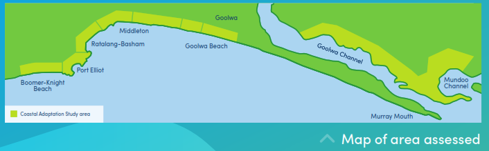
Alexandrina’s Coastal Adaptation Study assessed six key settlement areas:
- Murray Estuary Settlements (Mundoo and Goolwa Channels)
- Goolwa Beach
- Middleton
- Ratalang to Basham Beach
- Port Elliot
- Boomer to Knights Beach.
The majority of Alexandrina’s coastline has been identified as low-medium risk for future erosion and/or flooding. However, low lying areas, such as the dunes along Goolwa and Ratalang-Basham beaches, or the low lying areas in the Murray Estuary Settlements (Mundoo and Goolwa Channels), are identified as being at a potentially higher risk to flooding and erosion in the future (2050 and 2100).
The good news is that with identified risks and adaptation options, Council and stakeholders, such as State Government and private landowners, can prepare for the future. This requires ongoing monitoring and strategic planning of long-term adaptation options that will need to be assessed and revised regularly.
Following the study, Council adopted a Coastal Adaptation Plan that outlines a plan with actions and schedule for implementation.
You can access the full information by downloading the reports and factsheets below.
The Coastal Adaptation Study assessed the coast as a series of cells as illustrated on the map below.
Eight stand‐alone draft reports describe in detail the outcomes of the study for the separate coastal locations along our coast. The main draft report summarises the overall outcomes of the study and explains the methodology that was used to produce the location-specific reports.
- Alexandrina Coast Main Report
- Murray Estuary Settlements (Mundoo and Goolwa Channels), Hindmarsh Island
- Goolwa Beach, including Tokuremoar Reserve
- Middleton Beach
- Middleton Creek
- Ratalang to Basham Beach
- Port Elliot: Green Bay / Crockery Bay
- Port Elliot: Horseshoe Bay
- Boomer to Knights Beach.
If you don’t have time to read a series of long reports, take a look at our 2-page factsheets:
- Murray Estuary Settlements (Mundoo and Goolwa Channels)
- Goolwa Beach
- Middleton
- Ratalang to Basham Beach
- Port Elliot
- Boomer to Knights Beach.
Disclaimer
Alexandrina Council does not warrant or make any representation regarding the use, or results of the use, of the information contained in the Coastal Adaptation Study reports and factsheets as regards to their correctness, accuracy, reliability, currency or otherwise. The Council expressly disclaims all liability or responsibility to any person using or relying on information contained in the reports and associated documents.
Alexandrina Council values and recognises the role of the community in shaping our future. This is why we engaged from 12 October to 27 November 2020 with members of the community and key stakeholders about the findings of the study, to hear how the impacts of climate change might affect our coast into the future, and to learn about the possible adaptation options for Alexandrina’s coastline. The community had also the opportunities to provide an online feedback from, and ask questions and share feedback.
During the seven week public consultation period, three public online community webinars, and two invitation-only workshops for key stakeholders were held. You can access the summary reports below:
- Invitation-only Murray Estuary workshop 1 summary report (held 20 October 2020 )
- Invitation-only Murray Estuary workshop 2 summary report (held 27 October 2020 )
- Murray Estuary (Hindmarsh Island) webinar summary report (held 3 November 2020 )
- Goolwa/Middleton webinar summary report (held 12 November 2020 )
- Port Elliot/Boomer Beach webinar summary report (held 17 November 2020 )
The community could also provide feedback on the Coastal Adaptation Study through Alexandrina’s MySay page, through hard copy feedback forms at the Goolwa and Strathalbyn libraries, and via email. A summary of the outcomes of this feedback can be found here .
The Coastal Adaptation Plan was adopted by Council in 2022. The primary objective of the Plan is to provide a roadmap for Council, identifying priority works for the immediate, intermediate, and longer term. It will also help Council and affected stakeholders, such as private landholders and State Government, with the ongoing assessment and implementation of long-term adaptation options.
You can access the Coastal Adaptation Plan below: